
Kisan Path Investment Map 2026: 5 Gold Pockets to Buy & 3 Red Zones to Avoid
Sources: Amar Ujala, ETV Bharat, Patrika, Gaon Connection, UPEIDA and other news reports (linked in the article). Plot rates are DSD Properties on-ground estimates, not official rates. Last updated: 15 October 2026.
🔴 LATEST UPDATES — 15 October 2026
- 15 Oct 2026: An NHAI team inspected the damaged part of Kisan Path near Darogakheda, where a slab of the overbridge was damaged. (Amar Ujala)
- 14 Oct 2026: LDA plans to start passing building maps along Kisan Path under the new building bylaws. Until now LDA did not pass maps here. The proposal goes to the LDA board on 17 October. The report puts land near Kisan Path at about ₹3,000/sq ft (residential) and ₹5,000–6,000/sq ft (commercial). (Amar Ujala)
- 12 Oct 2026: LDA gave 800 plots in IT City (Sultanpur Road) to 534 farmers through a lottery. (ETV Bharat)
- 5 Oct 2026: Under the new rules, development authority boards can now approve land-use change for plots up to 6,000 sq m, and the fee is about half of what it was. (Amar Ujala)
- 28 Jul 2026: LDA ran bulldozers on illegal plotting across about 150 bigha in Chinhat, Kakori and Mal — 14 illegal colonies were cleared. (Patrika)
- 13 Jul 2026: The Lucknow–Kanpur Expressway was inaugurated and opened to traffic from 14 July. (Amar Ujala)
- 8 Apr 2026: UP Cabinet changed the Section 80 process: land-use change now becomes valid once the development authority approves the map. Separate SDM permission is no longer needed. (Gaon Connection)
- 10 Mar 2026: LDA launched IT City on Sultanpur Road; 549 people got plots in the first lottery. (Amar Ujala)
⚡ Why This Map Matters in 2026
- Kisan Path is fully open — all 104 km have been in use since March 2024
- LDA may soon pass building maps along Kisan Path — the LDA board takes it up on 17 October 2026, which can open the way for legal townships and colonies here
- Legal status decides the price — an approved plot and an unapproved plot next to each other can sell at very different rates
- Section 80 rules changed in April 2026 — land-use change now goes with map approval, so old "Section 80 in process" talk needs fresh checking
- LDA is acting on illegal plotting — 14 illegal colonies in Chinhat, Kakori and Mal were cleared in July 2026
With the Outer Ring Road fully operational, Lucknow's real estate map has been permanently redrawn. But here is what the generic "Kisan Path investment" headlines miss: the land you buy matters far less than the exact pocket within Kisan Path where you buy it. A short drive can take you from an LDA-approved layout to an unapproved colony on farm land — one with no passed map, no bank loan and almost no resale value.
This guide is built for serious investors and NRIs who want specific pockets with specific reasoning — not generic corridor hype. We identify 5 gold pockets where the fundamentals are strong, and 3 red zones where money regularly disappears. We also explain the April 2026 Section 80 change and LDA's new plan to pass building maps along Kisan Path.
📋 Table of Contents
- The "Kisan Path Era" — 2026 Context
- Why Generic "Kisan Path" Searches Are Dangerous
- Kisan Path on the Map: Junctions & Pockets
- The 5 Gold Pockets: Where to Invest Now
- The 3 Red Zones: What to Avoid in 2026
- The 2026 Legal Update: Section 80 & RERA
- Pocket-by-Pocket Price Comparison Chart
- Summary & 3-Point Action Plan
- Frequently Asked Questions
The "Kisan Path Era" — What 2026 Has Changed
Kisan Path — officially the Lucknow Outer Ring Road — stretches about 104 km around the entire city. After years of phased construction, PM Narendra Modi inaugurated the full ring in March 2024 (Amar Ujala). This was not an incremental change. It was a structural reset for Lucknow's geography.
Every major road out of Lucknow — Ayodhya (Faizabad) Road, Sultanpur Road, Raebareli Road, Kanpur Road, Hardoi Road, Sitapur Road — now crosses Kisan Path. The ring links these roads to each other, so you can go from one side of the city to the other without entering the city. Kisan Path passes through 43 villages of Lucknow district (Amar Ujala), and farm land in many of them now sits next to an 8-lane road.
The result: buyers who find Gomti Nagar Extension and other inner areas too costly are now looking at land near Kisan Path. The interest is real — and so is the risk of buying in the wrong pocket.
For broader context on Lucknow's real estate market trajectory: Lucknow Real Estate Market 2026–2027: Price Forecast & Investment Hotspots →
⚠️ Why Generic "Kisan Path" Searches Are Dangerous
This is the most important thing to understand before spending a single rupee on Kisan Path land: the corridor itself is not the investment thesis — the specific pocket within the corridor is.
Within a 2 km radius at virtually any point on Kisan Path, you can find both:
✅ Legal, High-Upside Plots
- LDA-approved schemes with registered maps
- UPRERA-registered developer projects
- Residential or commercial land use as per Lucknow Master Plan 2031
- Proper internal road widths shown on the approved layout map
- Clear Khasra numbers, clean Khatauni records
⚠️ Illegal, High-Risk Plots
- Unapproved Zila Panchayat colonies (241 blacklisted)
- Gomti flood-plain or green-belt land sold as "residential"
- Old colonies with narrow lanes and no approved layout
- Agricultural land sold as "residential" without conversion
- "Section 80 in process" claims with no passed map to show
The dangerous scenario for most buyers: the cheap plot and the legal plot look identical on a site visit. The difference only shows up in the documents — and most buyers don't know what to look for. This is where investors lose money on Kisan Path, not through fraud in the traditional sense, but through buying the wrong legal category of land.
📍 Kisan Path on the Map: Junctions & the 5 Gold Pockets
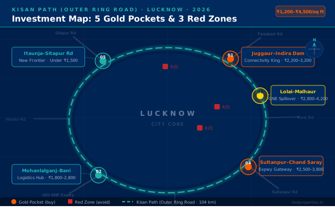
Kisan Path is the 104 km, 8-lane Lucknow Outer Ring Road that circles the whole city. PM Narendra Modi inaugurated it in March 2024 (ETV Bharat, UP Government). The orange line below is the ring itself, drawn from OpenStreetMap road data. Orange pins are the big roads that meet it, gold pins are the five Gold Pockets from this guide, and the red pin is Red Zone 3.
🗺️ Loading the Kisan Path map…
Tap any pin for details. Ring line and junction points: © OpenStreetMap contributors (ODbL). Map: Google.
The ring at a glance
- 1Juggaur — east, on Kisan Path near Ayodhya Road
- 2Mohanlalganj side — south, at the Raebareli Road junction
- 3Lolai–Malhaur — east, about 3 km inside the ring
- 4Sultanpur Road junction — south-east
- 5Itaunja — north, about 8 km beyond the ring on Sitapur Road
- !Chinhat interior — Red Zone 3, inside the ring
| Junction on Kisan Path | Direction from Hazratganj | Straight-line distance | What it connects |
|---|---|---|---|
| Kursi Road | North-east | ~18 km | Kursi Road meets Kisan Path in the north-east. |
| Ayodhya (Faizabad) Road | East | ~14 km | NH-27 towards Barabanki and Ayodhya. |
| Sultanpur Road | South-east | ~13 km | NH-731 towards Sultanpur. Gold Pocket 4 is this junction belt. The Purvanchal Expressway starts a few km further on, at Chand Sarai. |
| Raebareli Road (Mohanlalganj side) | South | ~14 km | NH-30 towards Mohanlalganj and Raebareli. |
| Kanpur Road | South-west | ~17 km | NH-27 towards Kanpur. The Lucknow–Kanpur Expressway (opened July 2026) runs on this side of the city. |
| Agra–Lucknow Expressway | West | ~15 km | The Agra–Lucknow Expressway meets Kisan Path in the west. |
| Hardoi Road (Kakori) | West | ~13 km | NH-731 towards Hardoi, near Kakori. |
| Sitapur Road (Bakshi Ka Talab) | North | ~18 km | NH-30 towards Sitapur. Gold Pocket 5 (Itaunja–Sitapur Road) lies north of here. |
🏆 The 5 Gold Pockets: Where to Invest on Kisan Path in 2026
We picked these five pockets for their road access, nearby projects that are already running, and price. The rates shown are DSD Properties on-ground estimates, not official rates — always check the current circle rate and the actual deal rate yourself.
1. Juggaur (Ayodhya Road side) — The Connectivity King
Of all the intersections on Kisan Path, Juggaur is the most strategically located for mid-term residential investment. It sits on Kisan Path about 2 km south of the junction with Ayodhya (Faizabad) Road — one of Lucknow's main roads — so you get both ring-road and city access.
📍 Why Juggaur Works
- BBD University complex — large student and faculty population generating consistent rental income
- Anandi Water Park — commercial anchor driving footfall, retail, and hospitality demand
- Faizabad Road connectivity — direct access to Hazratganj and old city commercial core
- Check every layout — the belt has both approved and unapproved layouts, so verify the LDA map before you pay
Rental yield here is driven by education demand — a more stable demand source than job-market cycles. BBD University has thousands of students, and many of them need rooms outside the campus.
2. Mohanlalganj Side (Raebareli Road) — The South Gateway
This pocket is where Raebareli Road (NH-30) crosses Kisan Path in the south. Mohanlalganj town itself is about 10 km further south on the same road. It suits buyers who want a lower entry price and can wait.
🛣️ What This Pocket Offers
- Raebareli Road (NH-30) — direct road to Mohanlalganj and Raebareli
- Kisan Path access — reach Sultanpur Road and Kanpur Road without entering the city
- Lucknow–Kanpur Expressway — open since July 2026 (Amar Ujala), but it runs on the Kanpur Road side, west of this pocket, not at this junction
- Lower entry price — cheaper than the east side of the ring
- Mostly farm land — check land use and LDA map approval before anything else
For comprehensive analysis of Mohanlalganj's broader investment case: Mohanlalganj Lucknow Property Guide 2026 — Prices, Projects, Risks & Expert Advice →
3. Lolai–Malhaur Stretch — The Residential Natural Extension
As Gomti Nagar Extension gets costlier, Lolai–Malhaur is the next residential layer. This stretch lies east of Gomti Nagar Extension, between Shaheed Path and Kisan Path.
🏘️ Why Lolai–Malhaur Has Structural Demand
- Green Corridor Phase 4 — a planned 6.3 km link along the Gomti from Shaheed Path to Kisan Path (Swarajya)
- Gomti Nagar Extension spillover — buyers who find GNE too costly look at this belt
- Malhaur Railway Station — rail access, which most outer areas don't have
- Close to Sultanpur Road — IT City and Wellness City are a short drive south
4. Sultanpur Road Junction — The Expressway Gateway
This pocket is the belt where Sultanpur Road crosses Kisan Path in the south-east. A few km further on, the Purvanchal Expressway starts at village Chand Sarai, about 1.7 km before Gosainganj (UPEIDA). LDA's IT City and Wellness City are also on Sultanpur Road, so this belt has several government projects already under way.
🚀 Confirmed Growth Drivers
- IT City (about 1,054 hectares) — 549 plots allotted in March 2026, and 800 plots given to farmers in October 2026 (Amar Ujala, ETV Bharat)
- Wellness City (1,474 acres) — LDA's township on Sultanpur Road (Amar Ujala)
- Purvanchal Expressway — starts at Chand Sarai on Sultanpur Road and links Lucknow to eastern UP
- Phoenix Palassio Mall — about 5 km from the junction
- Airport — CCS International Airport is about 16–17 km by road via Shaheed Path
For IT City's detailed investment case which directly drives demand here: LDA IT City Lucknow 2026: Plots, Price & Lottery Guide →
For Wellness City's detailed breakdown: Wellness City Lucknow 2026: LDA Plots, Price & Complete Buyer's Guide →
5. Itaunja–Sitapur Road Layer — The New Frontier
For NRIs and long-term buyers with patience, Itaunja is the low-price option. It is about 8 km north of Kisan Path on Sitapur Road, and most land is still farm land. Itaunja is in Lucknow district, which is the centre of the State Capital Region (SCR) notified in 2024 along with Hardoi, Sitapur, Unnao, Rae Bareli and Barabanki (Business Today).
🌱 The Long-Game Case for Itaunja
- State Capital Region — Lucknow district, including Itaunja, is part of the SCR
- Sitapur Road (NH-30) — direct road to Kisan Path and the city
- Lowest entry price in this guide — around ₹1,100–₹1,500/sq ft (DSD estimate)
- Low density — still mostly farm land, with few old colonies
- Long wait — plan for 5–7 years, not a quick resale
⚠️ Important: Itaunja Due Diligence is Critical
- Most land here is still agricultural (Krishi Bhoomi) — conversion to residential is mandatory before construction
- Verify LDA or UPAVP scheme approval before purchase — raw agricultural land without a development trigger has uncertain timelines
- 5–7 year horizon minimum — this is not a 2-year flip play
- Agricultural land conversion guide: Agricultural to Residential Land Conversion in Lucknow →
🔴 The 3 Red Zones: What to Avoid on Kisan Path in 2026
These are not theoretical risks. These are documented legal traps that have cost Lucknow buyers crores in the last 5 years. Knowing what to avoid is as valuable as knowing where to buy.
Red Zone 1 in Detail: The Unapproved Township Problem
LDA has officially published a list of 241+ blacklisted colonies in Lucknow — colonies that have been sold to buyers but have zero legal clearance. Many of these colonies are along or just inside Kisan Path, where dealers use the "ring road" name to sell unapproved plots cheap. In July 2026 LDA ran bulldozers over about 150 bigha of illegal plotting in Chinhat, Kakori and Mal (Patrika).
🚫 What Makes an Unapproved Colony So Dangerous
- No LDA layout map approval — the colony legally does not exist in government records
- No UPRERA registration — developer is operating outside the law
- Banks usually refuse home loans on unapproved plots
- Roads, water and sewer lines from the authorities are not guaranteed
- Subject to LDA demolition action at any time — no compensation paid
- Resale is effectively impossible — no buyer with financing will touch it
- Some colonies have been sold to multiple buyers — same plot, multiple "owners"
Check the full blacklist before any purchase: LDA Illegal Colony List Lucknow 2026: 241+ Areas to Avoid →
Red Zone 2 in Detail: Gomti Flood Plain & Green Belt
Kisan Path crosses the Gomti River, and land near the river can fall in the flood plain or be marked as green belt in the Lucknow Master Plan. Housing is not allowed on such land, however attractive the price looks.
⚖️ What This Means for Buyers
- Housing is not allowed on flood-plain or green-belt land
- Changing its land use is very hard — never buy on a promise that it "will be converted"
- Dealers selling this land often call it "near the river" or "riverside view property" — treat that as a red flag
- Check the land use on LDA's Master Plan 2031 map and ask at the tehsil about flood-plain status
Red Zone 3 in Detail: Chinhat Interior — Narrow Lanes, No Approved Map
This trap is harder to spot. Many older colonies in the Chinhat interior were cut by private dealers without an approved layout, with narrow internal lanes. Under the building bylaws, how much you can build — and whether a map can be passed at all — depends on the width of the road in front of your plot. In July 2026 LDA cleared illegal plotting in Chinhat, Kakori and Mal (Patrika).
📐 Why Road Width and an Approved Map Matter
- Many such colonies have no LDA-approved layout map
- Narrow lanes limit what building map LDA can pass for your plot
- Banks usually won't lend on such plots
- A low "discount" price often reflects these legal problems
- If you own such a plot: do not build without a passed map; talk to a property lawyer about your options
For a full comparison of LDA-approved vs. Zila Panchayat property and how to tell the difference: LDA vs Zila Panchayat Property in Lucknow — Which is Better? →
⚖️ The 2026 Legal Update: Section 80 & What It Means for Buyers
Section 80 of the UP Revenue Code deals with changing the use of farm land — for example, from agricultural to residential. Earlier, a separate permission from the SDM was needed for this, on top of the map approval. On 8 April 2026, the UP Cabinet changed this: once a development authority approves the map, the land-use change becomes valid with it, and separate SDM permission is no longer needed (Gaon Connection). In October 2026, Amar Ujala also reported that development authority boards can now approve land-use change for plots up to 6,000 sq m, with the fee cut to about half (Amar Ujala).
🚨 What This Means for "Section 80 in Process" Claims
- The change helps projects that get a proper map passed. It does not make an unapproved colony legal
- If a dealer says "Section 80 is in process" or "will be done later", ask for the passed LDA map and the RERA number. If they can't show them, walk away
- Land-use change still has to happen — under the new rule it comes together with map approval
- A Section 80 order on its own does not give you a building map inside the LDA area
✅ Legal Checklist for Kisan Path Plots (2026)
- LDA Layout Map Approval: Verify the layout map number with LDA (ldalucknow.in) — this is the main approval
- UPRERA Registration: Projects above 500 sq m or 8 units must be RERA-registered — verify at up-rera.in
- Land Use: Check the land use on the Master Plan, and that the farm-land conversion is done (now along with the map approval)
- Road Width: Read the road width on the approved map and match it on site — it decides what you can build
- No Acquisition Notice: Check at the Tehsil office that the Khasra number is not under any government acquisition
| Document / Approval | Where to Verify | Status Required |
|---|---|---|
| LDA Layout Map Approval | ldalucknow.in | Approved & valid map number |
| UPRERA Registration | up-rera.in | Active RERA registration number |
| Khatauni / Land Records | upbhulekh.gov.in | Seller name matches; no government note |
| Encumbrance Certificate | Sub-Registrar Office | No existing bank loan / mortgage |
| Mutation (Dakhil Kharij) | Tehsil Office | Completed in seller's name |
| Road Width | Approved layout map + site visit | Width on map matches the road on site |
| Acquisition Status | LDA / Tehsil | No active acquisition notice on Khasra |
📊 Pocket-by-Pocket Price Comparison
Kisan Path — Land Rates by Pocket (₹/sq ft, DSD on-ground estimates, 2026)
Not official rates. The range covers approved and unapproved plots in each pocket.
For a reference point from the news: Amar Ujala (14 October 2026) puts land near Kisan Path at about ₹3,000/sq ft for residential and ₹5,000–6,000/sq ft for commercial (Amar Ujala). Actual deal rates depend on the exact plot, road frontage and legal status.
| Tag | DSD Estimate (₹/sq ft) | Best For | |
|---|---|---|---|
| Juggaur (Ayodhya Road side) | Connectivity King | ₹2,200–₹3,200 | Residential + Rental |
| Mohanlalganj Side (Raebareli Road) | South Gateway | ₹1,800–₹2,800 | Lower entry, longer wait |
| Lolai–Malhaur | GNE Spillover | ₹2,800–₹4,200 | Residential (Premium) |
| Sultanpur Road Junction | Expressway Gateway | ₹2,500–₹3,800 | Residential + IT Worker Rental |
| Itaunja–Sitapur Road | New Frontier | ₹1,100–₹1,500 | Land Banking / NRI Entry |
| Red Zone: Unapproved Colonies | 🚫 Avoid | ₹1,200–₹1,800 | Do Not Buy |
✅ Summary & 3-Point Action Plan Before Paying Token Money
Before paying any token money on a Kisan Path plot — regardless of which pocket — run this 3-point checklist. These three checks have stopped more bad investments than any amount of market research.
⚡ The 3 Non-Negotiable Checks Before Any Kisan Path Purchase
-
Verify the RERA Number at up-rera.in
Every legitimate developer project must have an active UPRERA registration. No RERA number = no legal project. Search the project by developer name or project name at up-rera.in. A pending or expired RERA is also a red flag — valid only means currently registered and active. -
Check the Approved Layout Map and Road Width
Ask for the LDA-approved layout map — the stamped copy, not a brochure. Check that your plot is on it and read the width of the road in front of it. If there is no passed map, or the road on site is narrower than on the map, do not pay. -
Get the Possession Timeline in Writing (Registered Agreement)
A verbal possession commitment or a brochure date means nothing legally. Any developer serious about their project will execute a registered Agreement to Sell with the possession date, penalty clauses for delay, and refund terms clearly stated. Refuse any transaction without a registered agreement — this is your only legal protection against indefinite delays.
"Confused about a Khasra number on Kisan Path? Don't guess — verify. A 15-minute expert check can save you from a 15-year legal battle."
— DSD Properties, Lucknow Property Verification Experts📱 Free Verification — WhatsApp DSD Properties
- Khasra number verification — we check land records, acquisition status, and legal category
- Developer RERA check — we verify your developer's registration status and compliance record
- Pocket identification — tell us the location, we tell you if it's a gold pocket or a red zone
- Document review — share the layout map or agreement, we flag the issues before you sign
📚 Related Guides from DSD Properties
❓ Frequently Asked Questions — Kisan Path Investment 2026
What is Kisan Path in Lucknow?
Kisan Path is Lucknow's Outer Ring Road — a 104 km, 8-lane road around the whole city. PM Narendra Modi inaugurated it in March 2024. It links all the main roads out of Lucknow (Ayodhya Road, Sultanpur Road, Raebareli Road, Kanpur Road, Hardoi Road, Sitapur Road) and is now a big driver of new real estate on the city's outer edge.
Why are land prices on Kisan Path so different within the same area?
Plots close to each other can sell at very different rates. The main reason is legal status — LDA-approved and UPRERA-registered plots cost much more than unapproved Zila Panchayat or farm-land plots. Road access and nearby projects come second.
Which is the best pocket to invest in on Kisan Path in 2026?
For mid-term residential buying (3–5 years): Juggaur and the Sultanpur Road junction. For a lower entry price with a longer wait: the Mohanlalganj side (Raebareli Road). For NRIs and long-term land banking: Itaunja–Sitapur Road. Whichever pocket you pick, the plot must have an approved map.
Will LDA pass building maps along Kisan Path?
LDA has proposed passing building maps along Kisan Path under the new building bylaws. Until now LDA did not pass maps here. The LDA board takes the decision on 17 October 2026 (Amar Ujala, 14 October 2026). We will update this guide after the board meeting.
What changed in Section 80 in 2026?
Section 80 of the UP Revenue Code deals with changing farm land to non-farm use. On 8 April 2026, the UP Cabinet decided that the land-use change becomes valid once the development authority approves the map, so separate SDM permission is no longer needed. This does not make unapproved colonies legal. If a dealer says "Section 80 is in process", ask for the passed LDA map and RERA number.
How do I verify if a Kisan Path plot is LDA-approved?
Ask for the LDA layout map number and verify it with LDA (ldalucknow.in). Check the developer's UPRERA registration at up-rera.in. Check land records (Khatauni) at upbhulekh.gov.in to confirm the seller's ownership and look for any government acquisition note on the Khasra. If any of these steps can't be completed, do not go ahead with the purchase.
Is land near the Gomti on Kisan Path safe to buy?
Be careful. Kisan Path crosses the Gomti River, and land in the river's flood plain or marked as green belt in the Master Plan cannot be used for housing. Check the land use on the Master Plan 2031 map and the flood-plain status at the tehsil before you pay anything.
Is the Mohanlalganj side of Kisan Path a good investment?
It can suit buyers who want a lower entry price and can wait. The pocket is where Raebareli Road crosses Kisan Path; most land is still farm land, so check the LDA map and land use first. The new Lucknow–Kanpur Expressway (opened July 2026) runs on the Kanpur Road side, not at this junction. For more, see our Mohanlalganj 2026 Investment Guide →
Can I get a home loan for a Kisan Path plot?
Usually only for plots with a clear title and an approved LDA map (and RERA registration where the project needs it). Banks generally refuse unapproved Zila Panchayat plots, farm land and flood-plain land. If a bank won't lend on a plot, take that as a warning.
Why does road width matter for my plot?
Under the building bylaws, how much you can build — and whether LDA can pass your building map — depends on the width of the road in front of your plot. Old colonies in the Chinhat interior often have narrow lanes and no approved layout. Read the road width on the stamped LDA layout map and check it matches the road on site.
Leave a Comment